Thank you for visiting the Holkham Estate’s public exhibition for development on land at Dumpling Green, Dereham.
INTRODUCTION
Thank you for taking the time to visit our public exhibition and view our emerging proposals for up to 350 new homes to directly meet the needs of Dereham on land at Dumpling Green.
Members of the project team have provided information on a variety of elements associated with the scheme including: highways, drainage, ecology, landscape, trees and design.
We value local knowledge and welcome your input and feedback on the scheme. Comments received will be carefully considered so please help us shape the proposal by emailing your comments to info@arplanning.co.uk. Comments should be made by Friday 3rd October 2025.
PLANNING BACKGROUND
Land at Dumpling Green has been identified by Breckland Council as a sustainable location for the future growth of Dereham and it is expected to be included as a housing allocation in the new Local Plan.
The site’s identification as a preferred location for growth follows its submission to the Council’s Call for Potential Development Sites in 2022 and an ongoing process of consultation with Dereham Town Council, Breckland District Council planning officers and Norfolk County Council highways officers. The feedback and advice provided through this consultation has been used to develop the proposals including by making improvements to pedestrian and cycling infrastructure on Yaxham Road and the provision of superb play and informal sports provision.
The site is being brought forward directly by the Holkham Estate as the landowner.
Holkham’s direct involvement in this way brings many benefits. Holkham’s ambition is to be a force for good in helping local communities to thrive, by providing employment, homes, and support for local businesses and charities. They take a long-term approach and seek to create developments that will last for generations and that they are proud of.
In line with this ethos, Holkham are keen to understand local issues and design a scheme that positively addresses local needs

SITE LOCATION & FEATURES
- The site is located within the south of Dereham and extends to c.27 Ha.
- The site topography is defined by a shallow gradient from a low point in the southeastern corner of c.41m Above Ordnance Datum (AOD) to a high point in the northwest corner of c.51m AOD.
- The northern boundary defined by established hedgerow, tree planting and dwellings along Dumpling Green.
- The eastern boundary is delineated by existing dense hedgerow with a residential access track beyond.
- The western edge defined by established dense tree and hedgerow planting with Yaxham Road and associated dwellings beyond.
- The southern boundary formed by existing hedgerow and tree planting and the curtilage of Horseshoe Farm.
PROJECT TEAM
OPPORTUNITIES & CONSTRAINTS
Specialist consultants have undertaken technical assessments to ascertain the constraints and opportunities of the site
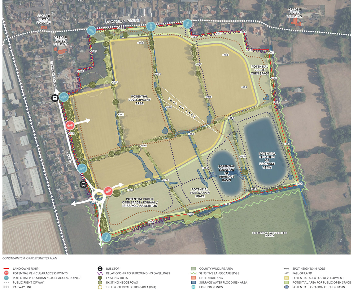
HIGHWAYS & ACCESS
- There is an opportunity to create a principal vehicular access off a new roundabout on Yaxham Road, with a potential secondary access point further along Yaxham Road to the north.
- There is the potential to deliver connections through to existing pedestrian / cycle routes on Dumpling Green to the north and Yaxham Road to the west.
- The existing Public Right of Way along Dumpling Green has the potential to be upgraded.
- Extensive cycle and pedestrian walking routes can meander through and around the periphery of the scheme, providing access to proposed amenities and services for both residents and visitors.
SURFACE WATER DRAINAGE
- All of the site is covered by a Flood Zone 1 designation suggesting the site is not at risk of flooding from rivers.
- Some small areas of the site are subject to surface water flooding. In order to manage this, a series of drainage basins would hold the water before allowing it to drain into local watercourses.
ECOLOGY
- Existing hedgerows and trees along the boundary will be retained and enhanced where possible.
- There is an opportunity to enhance biodiversity on site through proposed habitat creation, leading to a biodiversity net gain.
URBAN DESIGN
- There is an opportunity to create a considered arrangement of dwellings whilst respecting natural and physical constraints.
- Existing residential amenity will be protected, with proposed dwellings respecting the setting of existing homes.
- Houses on development parcels will face the street and spaces, ensuring that these are well overlooked, enhancing their safety for users.
TREES
- Trees and hedgerows will be retained where possible, and those trees deemed to be of high quality will be retained to form key focal points within the scheme.
LANDSCAPE & TOPOGRAPHY
- There is a level change across the site of c.10m. The high point is c.51m Above Ordnance Datum (AOD) in the northwestern corner and the low point is c.41m AOD in the southeastern corner.
- There is an opportunity to enhance and reinforce existing boundary vegetation through additional landscape buffer planting.
- There is the potential to offer extensive areas of publicly accessible open space in the north, east and south of the scheme.
- A major benefit of the scheme is the provision of a dedicated area for sports and recreation in the southwestern corner of the scheme.
LAYOUT & DESIGN
Design Response

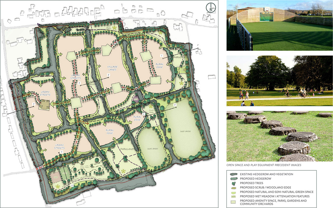
CONCEPT MASTERPLAN
Key principles of the masterplan include:
- Up to 350 dwellings in a variety of tenures.
- 25% of total dwellings to be affordable.
- Dwellings to be principally 2 storeys in height with some extending to 3 storeys.
- Principal vehicular access via a new roundabout on Yaxham Road to the west.
- Additional pedestrian / cycle access points onto Dumpling Green to the north and Yaxham Road to the west.
- Enhanced pedestrian and cycle routes outside the site boundary, including upgrades to existing footways to create pedestrian/cycle routes and new crossing points on Yaxham Road, providing connections to the services and amenities of Dereham to the north.
- Relocated and upgraded bus stops on Yaxham Road.
- Dumpling Green public right of way to be upgraded as part of proposals.
- Existing high quality trees and hedgerows retained and reinforced with additional planting.
- Landscape-led scheme with large green spaces creating a natural setting for dwellings.
- Provision of walking and cycling routes through expansive areas of public open space providing opportunities for relaxation and recreation.
- Large, dedicated area for formal sports and play provision in the southwestern corner of the scheme.
- Series of urban squares located along principal movement routes. Creates visual interest to the streetscene and assists with legibility.
- Outward facing perimeter block structure creates strong frontage and provides natural surveillance to streets and spaces.
- Variations in densities (the number of houses within each development parcel), with higher densities located around the main streets and lower densities on the scheme periphery.
- Additional tree and hedgerow planting throughout the proposed scheme providing landscape and ecological benefits.
- The proposed development proposes extensive habitat creation, offering an ecological Biodiversity Net Gain.
- Surface water managed by SuDS (Sustainable Drainage System) attenuation basins located at the site low point in the southeastern corner of the site. These collect surface water before controlling discharge into local watercourses.
LANDSCAPE & PUBLIC OPEN SPACES
Landscape, Open Space, Play & Sports Strategy
LANDSCAPE DESIGN PRINCIPLES
- Defined area for formal play incorporating play and recreation spaces for children and young people.
- Play and trim trails are proposed along the internal walking and cycling routes to encourage play and fitness.
- Grass verges are provided along streets where possible to allow for the planting of formal street trees.
- Variety of tree species proposed to enhance tree diversity and reduce future bio security risks.
- Existing boundary vegetation to be retained and used as a backdrop, encouraging ecological connections.
- Creation of well designed, overlooked areas of public open space, creating a safe, green framework for residents to enjoy.
- New species-rich grasslands and variety of tree species within proposed open spaces. Bound gravel footpaths lead residents through the surrounding open space.
- Connections with the existing Public Right of Way network enhances routes for users.
- Principal street planting to include low formal clipped evergreen hedgerows and seasonal ornamental shrubs
PLAY SPACES AND SPORTS PROVISION
The proposal has been designed to provide superb play and informal sports provision to meet the needs of the new development and the wider community. A dedicated area for sports, play and recreation is proposed to the southwest of the site that would have excellent pedestrian and cycle connections and car parking. This area would provide:
- Games Area: A Multi Use Games Area (MUGA) providing a versatile outdoor sports court uses for various sports like football, basketball and netball.
- Large Play Area: A Neighbourhood Equipped Area for Play (NEAP) providing a large community play space designed mainly for older children and teenagers but with play opportunities for younger users as well.
- BMX / MTB / Pump Track: A large pump track with varying difficulties to provide areas for experienced BMX and mountain bike riders and well as junior riders on bikes and scooters.
Additional areas for sports and play would be located across the site
including:
- Play Area: A Locally Equipped Area for Play (LEAP) providing a playground for younger children centrally within the development site.
- Walking and Cycling Routes: Extensive walking and cycling routes through the proposed open space areas to provide opportunities for walking, running and cycling.
- Play Trail: A trail through the proposed open space with regularly spaced naturally inspired play structures.

PLAY SPACES AND SPORTS PROVISION
HIGHWAYS & ACCESS
Additional information relating to access for vehicles, pedestrians and cyclists.

HIGHWAYS
Primary vehicular and pedestrian access is proposed via a new roundabout arrangement on Yaxham Road. This would incorporate new pedestrian crossing points, pedestrian and cycle routes and a relocated bus stop.
A secondary access junction is suggested further north along Yaxham Road.
Both access points would support a carriageway width of 5.5m with 2m pavements either side. Alongside vehicular access and egress, this access point allows safe pedestrian and cycle access to the services and amenities of Dereham town centre to the north
ACCESS
The existing Public Right of Way (PROW) along Dumpling Green would be retained and upgraded, accommodating new pedestrian and cycle connections from the proposed development.
Proposed pedestrian and cycle routes permeate through the proposed scheme. These allow access through the site both north to south and east to west, ensuring that residents and visitors are well connected to amenities both on site and within the wider area.
ECOLOGY, DRAINAGE & TREES
Proposed ecology, drainage and tree strategies for the site.

DRAINAGE
Surface Water
Parts of the site are subject to surface water flooding. In order to appropriately manage this surface water and additional run off from the built form and areas of hardstanding, a Sustainable Drainage System (SuDS) water management strategy has been developed.
This is proposed in the form of two drainage basins located at the low point of the site in the southeast corner. These basins seek to hold the surface water run off, before regulating the flow of this water into local watercourses, ensuring that surrounding land is not affected by increased surface water flows.
Foul Water
Assessments of the existing foul water network have determined that there is capacity within the system to accommodate additional waste associated with the proposed development.
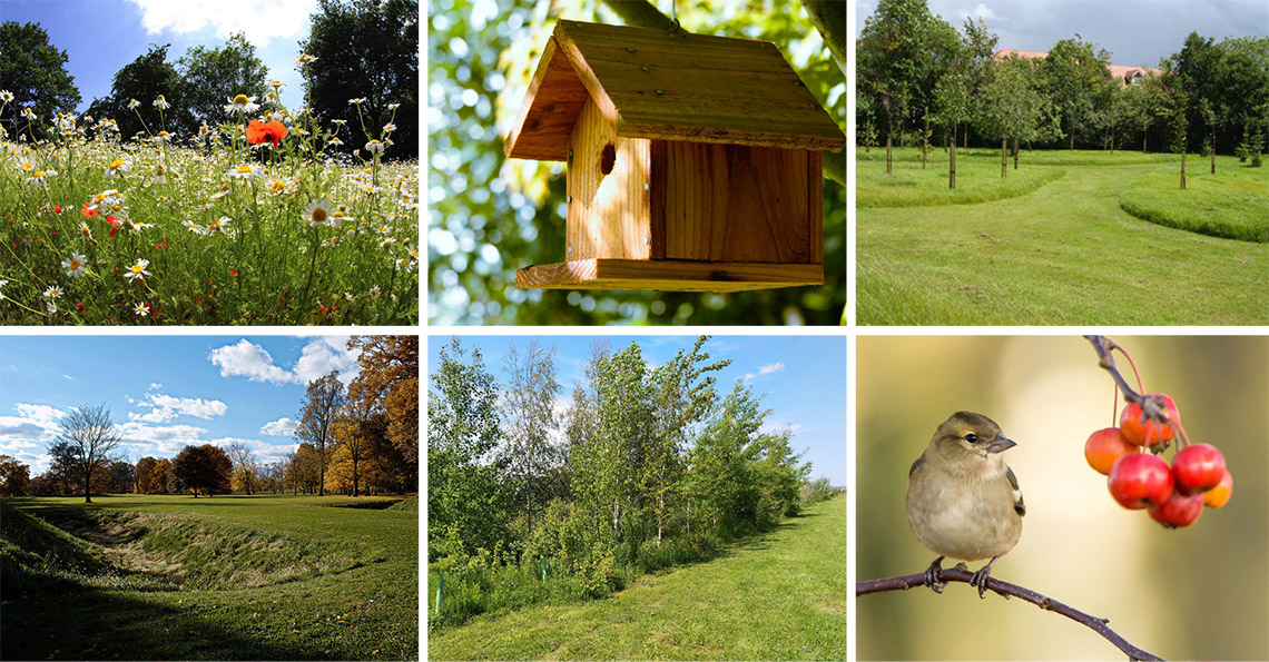
ECOLOGY STRATEGY
- The site is currently utilised for arable production, offering little wildlife value.
- The landscape proposals have been designed to provide an attractive greenspace for people that is also of value for wildlife, delivering substantial Biodiversity Net Gain (BNG).
Ecological features include:
- Creation of flower-rich grassland attractive to butterflies, bees and other pollinators.
- Native tree and scrub planting providing increased cover and habitats for wildlife.
- New species-rich native hedgerows.
- Enhancements for fauna including bat boxes, bird boxes, hedgehog runs, bee bricks and habitat piles.
TREE STRATEGY
- The site comprises individual fields divided by mature hedgerow and trees.
- These existing features will be retained within the site and along the site periphery where possible.
- Root Protection Areas (RPAs) have been respected throughout the scheme, ensuring that no built form occurs within the RPAs of retained trees and hedges.
- Some tree loss will occur where vehicle or pedestrian routes access or link the development parcels. However, these breaks have been designed to affect as few trees as possible.
- In order to replace those trees lost, an extensive landscaping strategy proposes the planting of additional native trees, hedgerows and shrubs.
- The creation of species-rich native hedgerows and flower-rich grassland attractive to butterflies, bees and other pollinators is also proposed.